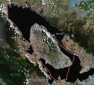
Lake Toba Expedition Route
 This is Geoff's GPS rendering of the actual route we took, on Google map. Geoff kept his GPS on the whole time, a luxury which my 10-year old unit was not able to keep up. The revised route as such:
Day 1: Tuk Tuk to Muara, 42km
Day 2: Muara to Sampean, 30km
Day 3: Sampean to Silalahi, 45km
Day 4: Silalahi to Tongging, 12km
The short 'overland' bit was when the GPS went out of batteries. That was also the place where we started the channel crossing to Muara. And one can see we probed Muara from the east before finally reaching it after paddling some distance west.
The other highlight of the first day, apart from the stormy night paddling, was the waterfall on the eastern shores of Lake Toba (as marked on the map). This impressive waterfall discharged directly into the lake.
 Since we were on kayaks, everyone attempted going underneath. Or at least we pretended to. The waterfall was simply too powerful and we had no doubt the kayak will suffered damage, not to mention the paddler as well, by its sheer power. Still we were serenaded by the cooling mist of water vapors created by the falls.


Comments
One comment - the first leg Tuk Tuk to Muara was actually 52km. Give us some credit!